Mount Leidy
Mount Leidy
Teton National Forest, Buffalo Ranger District
January 18th, 2009
Teton National Forest, Buffalo Ranger District
January 18th, 2009
 Mount Leidy
 While hunting Buffalo earlier this year, I had the opportunity to look at Mt. Leidy quite a bit. After reading more about Mt. Leidy in Thomas Turiano's "Select Peaks of Great Yellowstone" I decided it'd be a good ski objective this year. I knew the area and figured we could knock it out in a day trip if everything worked out. Matt Lloyd was game, so I picked him up a wee bit after 5:30am Sunday morning and headed up.
 Matt begins the skin up.
 We drove to the Hatchet Inn or Buffalo Ranger station and dumped the sleds there. From there we drove in about 19 miles. We took a bit of scenic detour on the "O" trail, which was good- it gave us a good look at the more northern aspects. Eventually we ended up taking the Leidy Lake road which puts you more on the more southern side of the mountain. Not really where we wanted to be with the warmer temperatures that were predicted. Regardless, we identified some ridgelines that looked safe and a little less exposed to the sun to begin our ascent on.
 Matt skins past some old avalanche debri.
 It wasn't long before our ridge line ended and we were forced to cross a run-out zone to get onto another ridgeline. The old avalanche debri was actually a good sign- chances were better that it wouldn't slide again.
 Matt gains the second ridge line.
 I thought that Mt. Leidy wouldn't be too challenging. An easy peak to bag, with what looked like tons of skiing options, including safer low angle treed runs. Not so. Everything leading up to the peak is steep and knife-edged.
 Matt makes his way around some brush, trying to stay on the ridge.
 A look out across a slope of Mt Leidy at this point, the Tetons in the background.
 Matt on top of a false summit, or the final ridge we would use to access the summit.
 Matt's view of me making my way up.
 You can see how challenging the skin up was. North facing cornices over a wind loaded slope on one side, and sun baked warming snow on the other. Both slopes were over 35 degrees. I was pretty nervous. Over the last two Januarys I've manage to trigger and get caught in avalanches on very similar looking terrain. Though the snow pack had been stabilizing this week, there's still a deadly layer (Nov rain crust) in there that we were concerned about.
 Mount Leidy's summit comes into view (Matt's making his way up).
 Matt nears the summit of Mount Leidy.
 On my way up.
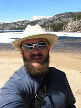
 Summit smiles.
 Taking it all in.
 A panoramic view from the summit of Mount Leidy.
(click to enlarge)
 Option #1
 Option #2
 Option #3 (the way we came up)
 We decided on option #3, slowly making our way back the way we came until we found something we could safely ski. First we had to modify Matt's ski binding. The heel piece on his Dynafit binding broke off, so we had to figure out a way to lock his heel down without it. Our solution hardly qualified as rocket science...
 Matt's new ultra light custom Dynafit binding (a piece of bailing wire).
 With his boot locked down with wire, Matt was ready to drop. He lead the way...

 We really eased into the first turns, dropping to safe spots and spotting one another.
 Making my way down, trying to stay on the ridge.
 Finally we hit a short section with room for a couple of turns.
 Dropping in and over to another ridge that looked like it might provide a good line or two down.
 Matt drops in.
 Wire binding seems to be holding.
 Wee hoo!
 Across the warming southern exposed gully (actually cut a small wet slide loose in it), Matt eyes a shady more northern ridge line that goes.
 I make my way on to the same ridge. From here we had good ski lines all the way down. Time to tear it up...
 Skiing Mt. Leidy!
 Good stuff!
 A look back at our lines.
 Another look from a bit further away.
 The terrain on Mt. Leidy and this area was pretty cool. Lots of ribbons and flutes. Runs ranged from 1000 to 15oo ft depending on the aspect.
The Matt Show
(He show's off how light his skis feel w/ his new binding)
 Looking down the last run of the day- a great north facing shot.
 Preparing for take off!
 Lift off!! Matt flies above Leidy Lake.
 Sticks it and skis it out, wire bindings and all!
 One last look back at the aspect of Mt. Leidy that we skied.
 A few more miles down the trail on our way back, and we get another final look at Mount Leidy (North Aspect).
 New country, no avalanches, didn't get lost or stuck- great day! With all of the unique terrain we saw, I'm guessing we might make it into this area again this year. It seems like we just barely nibbled on it. Can't wait to see what Matt can do to it when his gear's a 100%.
The route we took...
 Blue arrows indicate snowmobile route (15 miles?). Red is our climbing route (1 mile/ 1000 ft.)
(click to enlarge)
posted by Shad Hamilton at 11:49 AM
![]()

0 Comments:
Post a Comment
<< Home